Arsenio Butil Jr., a fisherman and pastor in Glan, Sarangani province, knelt to pray when the earth began to shake violently on June 8. The 7.8-magnitude earthquake that struck the southern Philippine island of Mindanao would prove to be the most powerful he had experienced in his lifetime. As the violent tremors subsided, however, Butil opened his eyes to witness something far more unusual than the destruction wrought by the quake itself: the coastline around him was visibly transforming, with expanses of once-submerged coral reef suddenly breaking the surface of the water.
The seismic forces unleashed by the shifting Cotabato Trench, which lies between 50 and 100 kilometres offshore, did more than topple buildings and trigger deadly landslides. In addition to claiming at least 76 lives across the island, the earthquake triggered a phenomenon known as coastal uplift—a dramatic vertical displacement of the earth's crust that permanently altered the geography of populated fishing communities. What had been familiar terrain to families who spent generations working these waters became, in the span of minutes, an unrecognisable landscape of jagged, dead coral walls stretching for kilometres in both directions along the affected shore.
Witnesses to the geological transformation described witnessing the ocean's behaviour during and immediately after the quake with palpable bewilderment. Butil recounted how water receded from the shore in a series of waves, advancing and retreating several times in succession. Dead fish floated on the water's surface as entire fishing boats that had once sat at the water's edge found themselves marooned on the wrong side of newly exposed coral formations. The scale of the physical change was staggering: according to initial assessments by the Philippines' seismology centre, the seabed rose approximately two metres, extending the shoreline by as much as 200 metres in some locations. The transformation affected a continuous stretch of coast spanning nearly 100 kilometres between two towns.
Nane Danlag, a scientist at the Philippines' seismology centre in General Santos City, confirmed the permanence of the coastal shifts while emphasising their naturally occurring context. The raised terrain would not subside; the new coastline represented the lasting result of tectonic forces operating beneath the island's crust. She noted that such vertical crustal movements had been occurring naturally for millennia as part of ongoing geological processes. The Cotabato Trench, the subduction zone responsible for the June 8 earthquake, represents one of Southeast Asia's most seismically active regions. A United Nations disaster risk reduction report released in mid-May had warned that thousands of small tremors recorded in January might herald a major seismic event—a prediction that proved grimly prescient.
The human cost of the geological upheaval extends far beyond the direct casualties from the earthquake itself. Approximately 100 people—fishermen, women, and children from a neighbouring village—remained encamped on higher ground weeks after the disaster, unwilling to return to their destroyed homes despite the passage of time. Datu Atom Malimpnig, a Maguindanaon chieftain, explained the psychological dimension of their reluctance to descend to the altered shoreline. Many evacuees remained convinced that another tsunami could strike, that the exposed seabed might suddenly surge forward again. For families whose livelihoods depended on the sea, the irrevocable transformation of the coastal environment represented not merely an inconvenience but an existential threat.
The economic ramifications of the coastal uplift proved equally devastating for the region's fragile tourism sector. At the Isla Jardin del Mar resort, located ten kilometres from the epicentre, staff confronted the grim reality of their transformed setting. Edzel Baylon, a resort worker, articulated the core problem with stark simplicity: the resort's primary commercial appeal—a white sand beach holiday experience—had become incompatible with the new geography. The ocean, once adjacent to pristine sands, now lay separated by an expanse of jagged, exposed coral. Water depths that had once invited swimming and water sports had become dangerously shallow. The resort's business model, predicated on coastal beauty and aquatic recreation, lay in ruins alongside the physical infrastructure damaged by the initial quake.
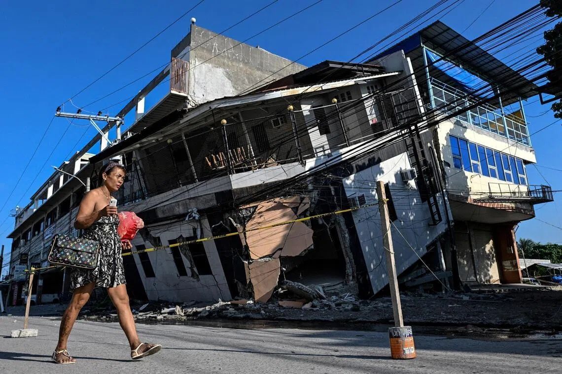
The aftermath of the June 8 earthquake witnessed continued geological instability that deepened community anxiety about rebuilding efforts. The seismology agency recorded more than 8,500 aftershocks in the weeks following the main quake, each tremor reinforcing the fear that another major seismic event could strike. Visible cracks spiderwebbed across the ground in Glan, stretching across extensive distances. Butil warned that the fractured terrain made any reconstruction effort perilous; structures built atop ground weakened by such extensive fissuring would remain vulnerable to collapse if another powerful earthquake occurred. As if to underscore the point, a 5.4-magnitude tremor shook the region as Butil spoke, a reminder that the Cotabato Trench remained active and unpredictable.
For Malaysian and broader Southeast Asian observers, the Philippine earthquake and its dramatic coastal consequences offer sobering lessons about the region's tectonic vulnerability. The wider western Pacific Ring of Fire encompasses numerous subduction zones and strike-slip faults that pose similar hazards to populated coastal areas throughout Southeast Asia and beyond. The Cotabato Trench incident demonstrates how a single major seismic event can permanently reshape the physical landscape, rendering communities literally unmoored from their traditional territories. It illustrates the inadequacy of conventional disaster preparedness frameworks that focus primarily on survival and rescue; long-term habitability and economic viability also hang in the balance when geological forces fundamentally alter coastal morphology.
The scientific understanding of these processes, while well-established in the geological community, remains poorly integrated into urban planning, infrastructure development, and resource management policies across the region. The Cotabato Trench's known seismic activity and January 2024 earthquake swarm—which experts recognised as a potential precursor—had generated warnings, yet the region's economic activities, tourism infrastructure, and settlement patterns had continued largely unchanged. Coastal uplift, though a slow geological process over millennia, can occur catastrophically during major earthquakes, transforming risk assessments overnight. The Philippine experience underscores the necessity for Southeast Asian governments to incorporate into planning frameworks the possibility of permanent environmental restructuring caused by major seismic events, particularly in densely populated coastal regions where livelihoods and economic activities concentrate.
%22%2F%3E%3C%2Fpattern%3E%3C%2Fdefs%3E%3Crect%20width%3D%22100%25%22%20height%3D%22100%25%22%20fill%3D%22url(%23ph19mfpg)%22%2F%3E%3Crect%20width%3D%22100%25%22%20height%3D%22100%25%22%20fill%3D%22url(%23ph19mfpp)%22%2F%3E%3Ctext%20x%3D%2250%25%22%20y%3D%2250%25%22%20text-anchor%3D%22middle%22%20dominant-baseline%3D%22central%22%20fill%3D%22rgba(255%2C255%2C255%2C0.95)%22%20font-family%3D%22Georgia%2C%20'Times%20New%20Roman'%2C%20serif%22%20font-weight%3D%22700%22%20font-size%3D%22170%22%20letter-spacing%3D%22-0.02em%22%3EMinistry%3C%2Ftext%3E%3C%2Fsvg%3E)