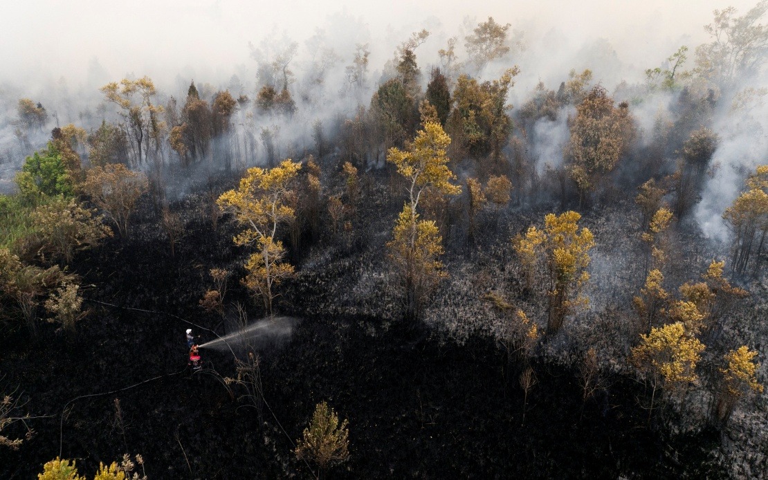
The aviation shutdown at Singkawang Airport on Saturday represents an escalating crisis across Indonesian Kalimantan as uncontrolled forest and land fires continue to choke the region with smoke. The airport authority announced the total suspension of all domestic flights through its Instagram account, citing safety imperatives and urging affected travellers to coordinate directly with their airlines. The facility, which serves the western portion of Indonesian Borneo approximately 145 kilometres north of Pontianak, the provincial seat of West Kalimantan, operates as a critical transport hub for the region.
The decision underscores how visibility constraints fundamentally threaten aviation operations in fire-affected zones. Indonesia's Transport Ministry disclosed that monitoring continues across multiple Kalimantan airports, with Lukman F. Laisa, the Directorate-General of Civil Aviation, emphasising that visibility thresholds constitute a non-negotiable operational boundary. When atmospheric conditions deteriorate below regulatory minimums, airlines face mandatory protocols: schedule disruptions, route diversions, or complete cancellations. Laisa stated in an official communication that aviation safety remains the paramount consideration, obliging operators to implement immediate modifications whenever environmental factors compromise operational standards. This regulatory framework reflects international aviation protocols, where visibility and ceiling measurements directly determine whether aircraft can safely approach and land at designated facilities.
Satellite monitoring from NASA's Terra and Aqua platforms revealed the magnitude of the fire situation across Kalimantan as of Friday evening. Central Kalimantan registered 56 high-confidence hotspots, whilst West Kalimantan, where Singkawang Airport is located, showed 51 active fire signatures. South Kalimantan contributed an additional 19 detected hotspots. These figures, detected at 9:30 pm local time, demonstrate a distributed fire pattern across the region rather than isolated incidents. The Meteorology, Climatology and Geophysics Agency (BMKG) corroborated the severity, confirming that portions of West and Central Kalimantan were experiencing very unhealthy air quality classifications. Such designations indicate particulate matter concentrations that pose genuine health risks to exposed populations and significantly impair visibility for ground-based and airborne operations.
Indonesian authorities have mobilised an extensive firefighting response combining terrestrial and aerial resources. Ground-based crews work continuously across affected areas, whilst water-bombing aircraft conduct aerial suppression operations targeting flame zones and reducing fire spread. Weather modification operations—cloud seeding techniques designed to induce precipitation—have been prepared and remain on standby for deployment once atmospheric conditions present suitable cloud formations. This integrated approach reflects the scale and complexity of managing forest fires across Kalimantan's expansive terrain, where dense vegetation and peat soils create conditions favouring fire persistence and smoke generation.
The investigative dimension adds a criminal justice component to the crisis. Central Kalimantan police have named approximately 12 suspects in connection with forest and land fire cases as of mid-August, according to Inspector-General Iwan Kurniawan, the provincial police chief. All fires falling under investigation undergo systematic examination to establish causation and identify responsible parties. The criminality aspect suggests that intentional or negligent human conduct contributed to fire initiation, distinguishing these incidents from natural fire occurrence. This investigative track record indicates institutional commitment to prosecuting those whose actions precipitated the environmental and economic damage.
For Malaysian stakeholders, the Kalimantan fire crisis carries immediate relevance beyond headline concern. Transboundary haze has historically affected Malaysia, particularly Peninsular Malaysia and Sabah, creating public health emergencies and respiratory illness clusters during peak fire seasons. The proximity of West Kalimantan to Malaysian Borneo intensifies cross-border air quality implications. Previous regional haze episodes have disrupted Malaysian aviation schedules, strained healthcare systems, and generated economic losses through reduced commercial activity and tourism impacts. This current outbreak therefore warrants vigilant Malaysian monitoring of atmospheric trajectories and air quality trends.
The Singkawang Airport closure also carries supply chain implications for regional commerce. Flight cancellations disrupt passenger movements, business travel, and express freight logistics servicing West Kalimantan's economic activities. Tourism flows experience immediate contraction as visitors abandon or defer travel plans during hazardous air quality periods. For Malaysian enterprises maintaining operations or commercial relationships within West Kalimantan, such disruptions create scheduling uncertainty and operational bottlenecks. The airport handles domestic traffic, meaning alternative routing options remain limited for those requiring rapid regional connectivity.
The underlying causation patterns merit regional attention. Indonesian forest management practices, agricultural land-clearing methodologies, and enforcement of fire prevention regulations directly influence haze generation and transboundary smoke movement. Peat soils characteristic of Kalimantan's landscape present particular fire challenges, as peat accumulations burn intensely and generate smoke volumes exceeding aboveground vegetation combustion. Climate factors including dry season intensity and precipitation patterns modulate fire risk and persistence. These environmental and management dimensions transcend national boundaries, creating shared atmospheric and ecological consequences across Southeast Asia.
Indonesian coordination mechanisms involving multiple ministries, provincial authorities, and scientific agencies demonstrate institutional mobilisation capacity. The Transport Ministry's real-time monitoring, BMKG's atmospheric assessment, police investigative operations, and firefighting deployment represent integrated crisis response architecture. However, sustained effectiveness depends on resource allocation consistency, inter-agency communication efficiency, and follow-through on criminal prosecutions. International cooperation frameworks, including air quality data sharing with regional neighbours and collaborative firefighting technical assistance, strengthen collective regional resilience against repetitive haze cycles.
The immediate forecast for Singkawang Airport and regional air conditions depends on firefighting progress and weather pattern evolution. Should suppression efforts contain active fires and clear skies return, flight resumption timelines shorten considerably. Conversely, sustained fire activity and unfavourable wind patterns prolong visibility impairment and operational closure durations. Indonesian authorities' public communications emphasising passenger safety and coordination with airlines suggest managed expectations regarding near-term resumption prospects. The situation exemplifies climate change adaptation challenges facing tropical Southeast Asia, where intensifying dry seasons and changing precipitation patterns create expanding fire management pressures across the region.

