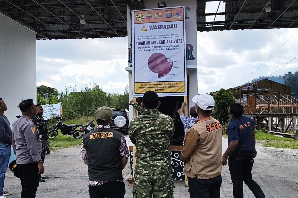
Authorities in Indonesia's North Sumatra province have moved swiftly to seal off key tourism destinations following a marked escalation in volcanic behaviour at Mount Sinabung. The Karo regency administration implemented an indefinite suspension of access to Lau Kawar Lake and adjacent recreational facilities in Kuta Gugung village, Naman Teran district, commencing August 19. The decision came after the Vulcanology and Geological Disaster Mitigation Center's monitoring station detected a pronounced uptick in the volcano's seismic and atmospheric activity, prompting a formal recommendation to restrict public movement in the area.
The closure represents a precautionary response to changing geological conditions rather than an imminent catastrophic event, officials emphasised. Juni Antomi Kemit, head of the Karo Youth Affairs, Sports and Tourism Agency, characterised the measure as essential protection for both resident communities and visiting tourists who frequent the region's natural attractions. A public directive issued by the Karo regent on August 14 had already urged residents, visitors, and mountaineers to abstain from any activities in the immediate vicinity of the volcano, but the subsequent escalation of warning levels necessitated formal tourism sector restrictions.
Mount Sinabung's threat designation moved from Level I Normal to Level II Waspada—the second rung on Indonesia's four-tier alert framework—triggering expanded exclusion zones around the 2,460-metre peak. Armen Putra, who oversees the dedicated monitoring post at the volcano, indicated that authorities now recommend maintaining a three-kilometre perimeter from the summit, with an expanded 4.5-kilometre radius of caution extending into the south-east sector. These geographic boundaries reflect scientific assessment of potential hazard dispersal patterns and provide graduated buffers reflecting varying risk profiles across different directions.
The escalating seismic signature detected by monitoring instruments points to mounting internal pressure within the volcanic system. Between Thursday's early morning observations alone, instruments registered five distinct volcanic earthquakes originating from within the mountain, alongside additional tectonic earthquakes unrelated to magmatic processes. Wednesday's data had shown only one volcanic earthquake against seven tectonic events, underscoring the acceleration in internally-generated tremors over consecutive days. Armen cautioned that heightened frequency and intensity of seismic events correlate directly with increased eruption potential, though such activity does not guarantee imminent discharge.
Visual observations complement the instrumental data driving official concern. Monitoring teams have documented substantial steam and gas emissions reaching heights of 100 to 800 metres above the summit, indicating vigorous degassing from the shallow magma system. The combination of multiplying earthquakes and visible plume activity creates a pattern consistent with magma moving progressively closer to the surface, even if such movement does not necessarily culminate in eruption. Residents dwelling along river valleys that drain Mount Sinabung's slopes face particular hazard exposure, as saturated volcanic material can mobilise into destructive lahars—superheated mud flows capable of travelling considerable distances downslope.
Mount Sinabung's modern eruptive history spans little more than a decade, yet encompasses episodes of remarkable violence. The volcano had remained quiescent for approximately four centuries until August 29, 2010, when it suddenly reawakened with a substantial eruption. Activity subsided within weeks, but the volcano reasserted itself on September 15, 2013, initiating a protracted phase of intermittent but significant activity. That year witnessed a major eruption in November that escalated the alert status to Level IV Awas—the maximum warning designation—and generated pyroclastic flows that killed numerous individuals while forcing evacuation of residents from 21 villages and two hamlets across the region.
The volcano's behaviour over the following six years reflected the challenge of managing communities adjacent to active volcanic terrain. Continuous eruptive episodes characterised the 2013-2019 period, during which thousands of residents existed under conditions of perpetual displacement or restricted movement. Only in May 2019, following months of analysis indicating diminishing threat indicators, did authorities downgrade the alert status to Level III Siaga—the watch designation—permitting gradual restoration of normal activities. This provisional normalcy lasted barely two years before Mount Sinabung demonstrated renewed vigour.
July 28, 2021, marked the most recent major eruption, projecting ash columns to heights exceeding 4,500 metres and unleashing pyroclastic flows extending over a kilometre in the east-south-east direction. Five districts experienced significant ash fall, creating hazardous conditions for agriculture, transportation, and public health across an extensive area. The eleven-year span of continuous eruptive activity, punctuated by phases of relative quiescence but never true dormancy, illustrates the complex nature of Mount Sinabung's volcanic system and the challenges facing regional administrators attempting to balance economic activity with genuine safety imperatives.
The current alert elevation represents the latest chapter in an exhausting cycle of volcanic unrest, social disruption, and regulatory response that has defined the North Sumatra region's relationship with Mount Sinabung for over a decade. For Malaysia and other Southeast Asian nations hosting active volcanic or seismic hazards, the case study demonstrates the operational burden of managing long-term volcanic risk. Tourism-dependent economies must weigh immediate revenue concerns against documented hazard patterns and expert scientific guidance, a calculus that Indonesia has increasingly resolved in favour of precaution following the catastrophic consequences of prior underestimation.
The closure of Lau Kawar Lake and associated facilities, while economically costly to local operators and disappointing to potential visitors, reflects institutional learning from previous crises. Indonesian disaster management protocols have matured substantially since 2010, incorporating international best practices and real-time scientific monitoring. The decision to act decisively upon alert level changes, rather than deferring action pending clearer evidence of imminent eruption, represents a professional advancement that prioritises community welfare over competing commercial interests. For the broader Southeast Asian region, such developments underscore the necessity of sustained investment in volcano monitoring infrastructure and the development of robust early-warning systems capable of providing populations with the lead time required for orderly evacuation and protective action.

