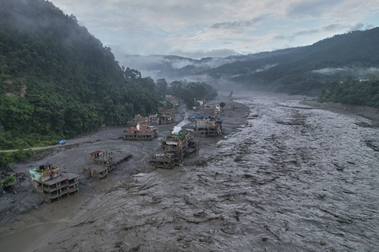
Nepal's worst environmental disaster in decades has laid bare a critical infrastructure failure: the nation's inability to detect and warn of dangers brewing in the remote, ice-capped mountains that tower along its northern frontier. When a glacial collapse triggered the devastating floods on August 26, residents in the impact zone had mere minutes—sometimes fewer than five minutes—to attempt escape before walls of ice, mud, rock and water obliterated everything in their path. The catastrophe, which has claimed at least 800 lives and left more than 3,000 missing, underscores a sobering reality that extends far beyond Nepal's borders: the Himalayan region lacks the coordinated monitoring systems necessary to protect millions of people living downstream from increasingly volatile high-altitude hazards.
Dharam Raj Uprety, who leads Nepal's National Disaster Risk Reduction and Management Authority, attributes the warning gap directly to two interconnected failures. First, Nepal has virtually no weather stations positioned in its highest mountains, where the most dangerous changes occur. Second, and perhaps more critically, there are no functional mechanisms for sharing real-time meteorological and climate data across the Nepal-China border. Uprety describes this absence of transboundary data exchange as one of his nation's "biggest challenges," a candid acknowledgement that Nepal's disaster response framework depends on cooperation that currently does not exist in any formal or systematic way.
The geography of the problem compounds its severity. Climate scientists have long recognised that the Tibetan Plateau and the high Himalayas are warming faster than almost any other region on Earth. This accelerated warming destabilises permafrost that binds mountain slopes together and weakens the structural integrity of glaciers. As temperatures climb, new lakes form within and atop glaciers—bodies of water that can catastrophically breach their ice dams with little warning. Yet Nepal's monitoring capacity largely ends in the foothills. The nation's existing early-warning infrastructure focuses on downstream river systems and lower elevations, leaving vast swathes of the high mountains essentially blind spots on the meteorological map.
Building and maintaining weather stations at extreme altitude presents formidable obstacles beyond mere geography. The cost is substantial; the technical demands are severe; and staff safety in such remote, dangerous terrain is a perpetual concern. These practical constraints explain why many developing nations, including Nepal, have been unable to deploy adequate monitoring networks in their mountain territories. Yet the consequences of this gap are being measured now in thousands of lives lost and incalculable suffering.
China has publicly acknowledged the challenge. Following the Nepal disaster, President Xi Jinping directed accelerated surveying of glaciers and glacial lakes across the Tibetan Plateau and ordered stronger monitoring and early-warning systems nationwide. The Chinese Communist Party's move suggests Beijing recognises that these hazards transcend borders. However, when the Chinese Embassy in Nepal issued a statement on the social media platform X, it spoke only in general terms about making "every effort, within the limits of existing technologies," to monitor and share information with Nepal. Notably, the embassy did not specify whether China had provided any advance warning about the August 26 event, nor did it detail the actual mechanisms or timeliness of data sharing between the two countries.
The silence on specifics is revealing. While China and Nepal maintain what both countries describe as "close communication on transboundary disaster management," there is no indication that this communication translated into actionable intelligence that could have bought communities even an additional hour of preparation time. For a region where glacial hazards originate primarily upstream in Tibet and Bhutan, the absence of real-time cross-border data sharing represents a fundamental vulnerability. Communities in Nepal are essentially waiting for disasters to arrive with no advance knowledge of conditions developing in the mountains above them.
The economic implications extend beyond the immediate human toll. Initial estimates suggest the damage could exceed US$5 billion, a staggering sum for one of South Asia's poorest nations. Reconstruction could consume seven to eight years, mirroring the protracted recovery from Nepal's devastating 2015 earthquake. Tourism, which generates crucial foreign exchange and employment across the Himalayan region, will likely suffer as international visitors remain wary of travel to affected areas. The broader Southeast Asian economy, which depends on stable supply chains and cross-border movement of goods and people, will feel secondary effects from Nepal's disruption.
What triggered the August 26 disaster itself was a bedrock collapse beneath a glacier—a failure of the underlying rock and earth that suddenly unleashed the ice mass above it. Satellite analysis confirmed this mechanism, but scientists have cautioned against jumping to definitive conclusions about climate change's direct culpability in this particular collapse. However, they emphasise that warming temperatures weaken the permafrost that acts as a cement binding high-altitude slopes together. Over time, this weakening accumulates, creating conditions where sudden catastrophic failures become more likely. The tragedy, in other words, may be partly attributable to long-term climatic shifts, even if the precise trigger was geological.
Uprety has signalled that improving early-warning capacity is now a top priority for Nepal's disaster management establishment. His authority has drafted a comprehensive roadmap intended to be formally endorsed in the coming months. The plan focuses on extending detection and warning systems into higher elevations and, crucially, on accelerating the timeline between hazard detection and community notification. Yet the roadmap's success hinges on factors largely beyond Nepal's control—specifically, China's willingness to share glacier and weather data in real time and to establish formal protocols for cross-border alert systems.
The broader lesson resonates across the entire Southeast Asian region. Many nations in this part of the world depend on upstream water sources originating in or flowing through higher-altitude zones where monitoring is inadequate. Thailand's water security, Laos' hydroelectric infrastructure, Vietnam's Mekong Delta stability, and Myanmar's agriculture all depend on weather and hydrological conditions in areas where data sharing remains fragmented or nonexistent. Nepal's tragedy demonstrates what happens when transboundary cooperation on environmental monitoring fails: communities downstream pay with their lives.
Uprety's final point captures the essential problem with particular clarity. "Unless we stop making boundary for climate information," he said, referring to the way national borders constrain the free flow of meteorological data, "disasters originating in remote mountain areas will remain difficult to anticipate." Climate systems do not respect political boundaries. Glaciers melt across borders; storms develop in international airspace; mountain water systems connect nations whether or not governments wish them to. The choice facing regional governments is whether to accept that climate information and disaster risk must be managed collaboratively, or to continue accepting the tragic losses that result from fragmented, siloed approaches to shared environmental challenges.

