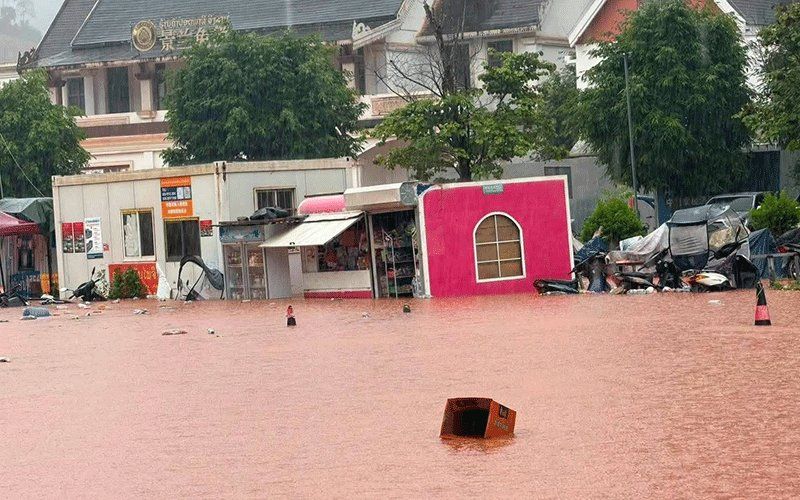
Luang Namtha province in northern Laos activated official disaster protocols on Saturday, August 29, after destructive flash floods swept through the region near the Laos-China border crossing at Boten. The provincial administrative committee's declaration underscores the scale of the inundation that has engulfed communities, commercial zones, and vital infrastructure across more than 30 affected villages in the northern reaches of the country.
The flooding event itself emerged from a cascade of hydrological factors that overwhelmed local drainage systems and river capacities. Heavy rainfall across several days saturated upstream watershed areas, causing multiple tributaries to swell rapidly and channel enormous volumes of water downstream into Laotian territory. The Tha River, a critical waterway in the region, recorded readings of 6.58 metres at its hydrology monitoring station—well above the established 6-metre warning threshold and approaching the dangerous 7-metre flood level that signals potential for catastrophic overflow. This rapid water level escalation reflects the intensity of precipitation and the saturation conditions in the broader catchment area.
The scale of physical damage spans multiple sectors vital to provincial functioning and economic activity. Residential structures situated near riverbanks and watercourses experienced inundation or partial submersion, leaving residents displaced or stranded. The Boten special economic zone, a strategically important commercial area designed to facilitate cross-border trade and investment, lay vulnerable to the surging waters. Agricultural lands stretching across the plains were overwhelmed, threatening harvests and rural livelihoods. Public institutions including schools and healthcare facilities reported damage or disruption to services. However, the border checkpoint facility itself remained operational and unaffected by the disaster, allowing continued essential cross-border functions despite the broader humanitarian emergency.
Luang Namtha and Nalae districts bore the brunt of the disaster, with both areas experiencing widespread flooding and concurrent landslide events. The combination of excess water and soil saturation in a mountainous region created compounding hazards, as hillsides destabilized and shed material downslope. This dual-threat environment—simultaneous flooding and landslides—significantly complicated emergency response and elevated risks to vulnerable populations in elevated or sloped terrain throughout the affected districts.
Government response mechanisms mobilized swiftly following the disaster declaration. The Department of Meteorology and Hydrology, operating under the Ministry of Agriculture and Environment, issued formal flood warnings for the Tha River covering the critical 48-hour period of August 29-30. Authorities in five districts received explicit directives to activate community alert systems targeting three vulnerable populations: residents dwelling along riverbanks exposed to overflow risks, communities in topographically low-lying areas prone to water pooling and prolonged inundation, and populations in other geographically or structurally vulnerable locations. Provincial leadership instructed local administrators to implement continuous monitoring protocols, respond decisively to emerging incidents as they developed, and maintain regular communication lines reporting situation updates to provincial headquarters.
The immediate meteorological context extends well beyond Luang Namtha's borders, with a broader atmospheric pattern threatening the wider northern region. A low-pressure weather system is traversing northern Laos and adjacent southwestern Chinese territories, interacting with the south-westerly monsoon circulation. This combination generates conditions highly conducive to organized precipitation—scattered thunderstorm development punctuated by periods of moderate to heavy rainfall, accompanied by gusty wind events. These conditions are forecast to persist through the weekend across 14 provinces spanning northern and central Laos.
The provincial roster facing elevated weather and flood risk illustrates the geographic reach of this meteorological event. Northern provinces including Phongsaly, Huaphan, Luang Prabang, Oudomxay, and Xaysomboun face exposure, as do central regions such as Xaysomboun, Bolikhamxay, Khammuan, and Savannakhet, plus southern provinces including Salavan, Xekong, Champasak, and Attapeu. Even the capital region around Vientiane falls within the warning zone. This territorial expanse reflects the scale of the atmospheric disturbance and the synchronized nature of Laotian monsoon dynamics across multiple provinces.
For Malaysian and Southeast Asian observers, the Luang Namtha flooding carries broader significance extending beyond immediate humanitarian concerns. The incident highlights how monsoon-driven weather patterns and hydrological systems operate across porous borders in mainland Southeast Asia, affecting multiple nations simultaneously. Cross-border infrastructure like the Boten economic zone and checkpoint demonstrate how transnational commercial frameworks intersect with regional weather vulnerabilities. The rapid response framework Laotian authorities have implemented—coordinated warnings, district-level mobilization, vulnerable population targeting—represents a regional model for disaster preparedness in a zone where monsoon flooding represents an recurring annual challenge.
The agricultural impacts particularly resonate for the broader region, where rice cultivation and crop production sustain rural populations across Laos, Thailand, Cambodia, and Myanmar. When flash floods destroy standing crops or inundate agricultural land during critical growing seasons, the consequences cascade through food security networks and rural economies across national boundaries. Supply chains for regional agricultural products experience disruption, affecting market prices and availability throughout Southeast Asia.
Long-term considerations for Laos centre on infrastructure resilience in border regions where economic zones and trade corridors face repeated exposure to seasonal flooding. The Boten special economic zone represents significant Chinese investment and regional trade infrastructure, making its recurrent vulnerability during monsoon periods a concern for bilateral economic relations and cross-border commerce patterns. Adaptation strategies—including enhanced drainage infrastructure, early warning systems, and land-use planning modifications—become increasingly relevant as climate patterns potentially intensify extreme weather events in future seasons.
Residents throughout the 14-province warning area have received official guidance to remain vigilant regarding meteorological forecasts, maintain situational awareness regarding their local environment and river conditions, and prepare evacuation arrangements if rapid water level increases create imminent threats. This layered preparedness approach—combining technical monitoring through hydrology stations, institutional coordination through provincial administration networks, and community-level readiness among threatened populations—represents the operational foundation for disaster response in Laos's most flood-vulnerable regions during high-risk monsoon periods.

