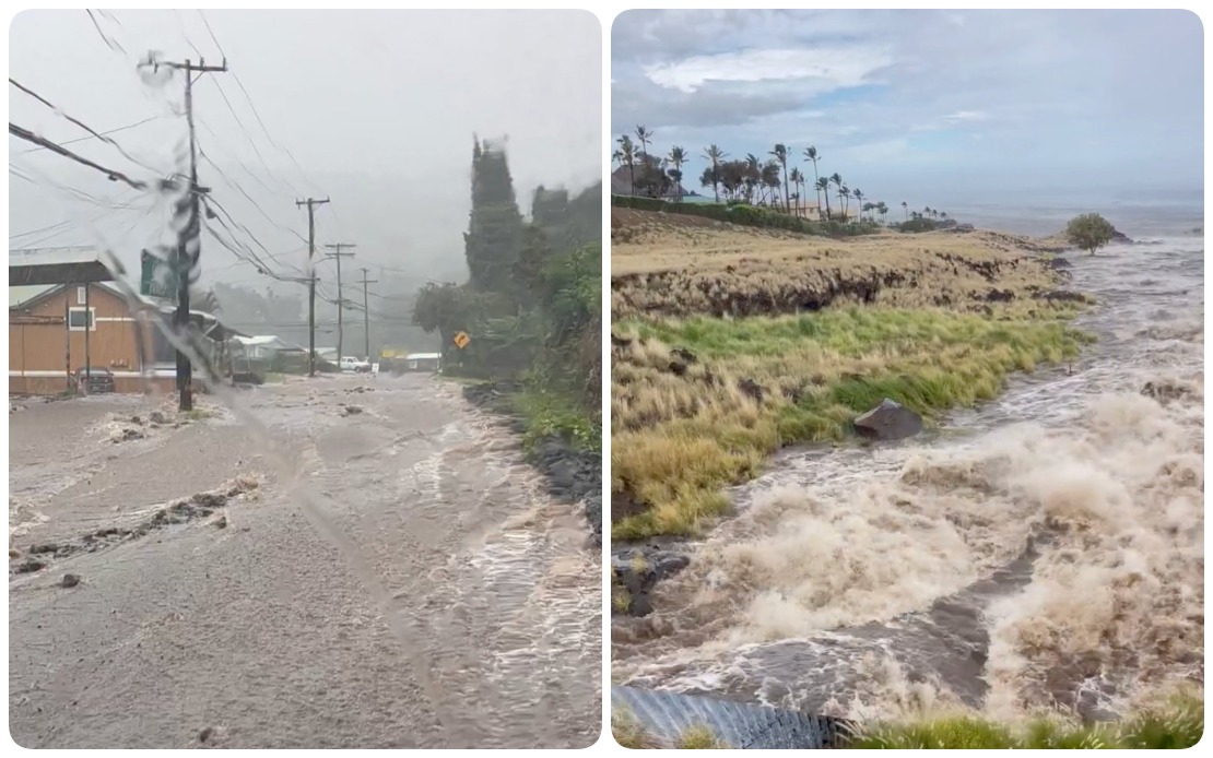
Hurricane Lala delivered a severe blow to Hawaii on Saturday, August 15, as the powerful storm system swept across the archipelago with destructive winds and intense rainfall, leaving tens of thousands of residents without electricity and forcing authorities to implement emergency shelter protocols across multiple islands. The hurricane's track brought it dangerously close to Hawaii Island, where the most severe impacts were concentrated, though the broader storm system affected Maui County, Oahu, and Kauai as conditions deteriorated throughout the day.
According to Governor Josh Green, wind speeds on Hawaii Island reached critical levels during the afternoon and evening hours, with meteorological stations recording gusts approaching 90 mph in exposed coastal areas. The rainfall distribution proved equally concerning, with some localities accumulating more than 13 inches of precipitation, triggering flash flooding alerts across low-lying communities and drainage-prone regions. The governor indicated that conditions were actively worsening on the neighboring islands, signalling that the storm's impact zone was broader than initial projections had suggested.
Electrical infrastructure bore the brunt of the hurricane's mechanical force. Hawaiian Electric, the primary utility serving the islands, reported that 88,000 customers had lost power by 7 p.m. local time, with the outages distributed across the affected regions according to storm intensity. Hawaii Island experienced the most severe electrical disruption, with 63,270 customers disconnected from the grid—a reflection of the storm's core passing in close proximity to that location. Maui County accounted for approximately 15,260 outages, whilst Oahu, though further from the hurricane's centre, still experienced roughly 9,500 customers without service.
The transportation network suffered multiple casualties from fallen trees and debris. The Hawaii Department of Transportation documented road closures spanning Hawaii Island, Maui, and Oahu, with video documentation showing streams bursting their banks and roadways submerged under moving water. Local law enforcement reported widespread traffic disruptions, including the closure of Kahikopele Street in Mountain View and significant impact to Pauahi Street. The Mamalahoa Highway saw multiple warnings issued due to accumulating debris and downed vegetation, whilst downed power lines necessitated the closure of Plumeria Street, creating additional complications for residents attempting to navigate their communities.
The infrastructure damage extended well beyond individual trees and poles. Hawaiian Electric reported that fallen vegetation brought down multiple utility structures along a 42-mile transmission line corridor on the Hamakua coast, suggesting systematic damage to the backbone of the electrical distribution system rather than isolated incidents. This extensive infrastructure compromise meant that restoration crews faced significant logistical challenges in reestablishing service, particularly across areas already without electricity.
Emergency management officials confirmed that flooding, power outages, hazardous wind conditions, and downed trees were being reported with alarming frequency across Hawaii Island. The Hawaii Emergency Management Agency's assessment underscored the multi-faceted nature of the disaster, which simultaneously threatened public safety through wind-borne hazards, compromised critical infrastructure, and created access challenges for emergency responders. Authorities urged residents to remain sheltered in place or relocate to designated community shelters, recognising that continued exposure to outdoor conditions posed unacceptable risks.
Utility officials indicated that customers on Hawaii Island and Maui who had already lost power would likely remain without electricity through the night and potentially beyond. The assessment reflected dangerous field conditions that prevented restoration crews from safely accessing damaged infrastructure. Wind speeds that remained elevated, ongoing precipitation, and residual hazards from debris made it impossible to conduct repair work with adequate safety margins. The utility essentially communicated that restoration would necessarily await weather improvement and daylight conditions, leaving many residents facing an extended period without essential services.
The hurricane's impact on Hawaii carries broader significance for Pacific island communities and disaster preparedness systems across the region. As climate patterns continue to evolve, extreme weather events striking populated areas with minimal warning present escalating challenges for infrastructure designed to legacy standards and emergency response systems calibrated to historical precedent. Hawaii's experience with this storm provides valuable insights into vulnerability assessment and recovery logistics that extend beyond the immediate islands affected, informing preparedness planning across Southeast Asia and the Pacific Basin.
For Malaysian and regional readers, Hurricane Lala serves as a sobering reminder of the natural hazards that persist in tropical and subtropical regions, including Southeast Asia's own hurricane-prone waters. The storm's rapid intensification and track changes underscore the importance of robust early warning systems, infrastructure redundancy, and community preparedness frameworks—lessons particularly relevant as climate change potentially influences storm frequency and intensity throughout the region.

