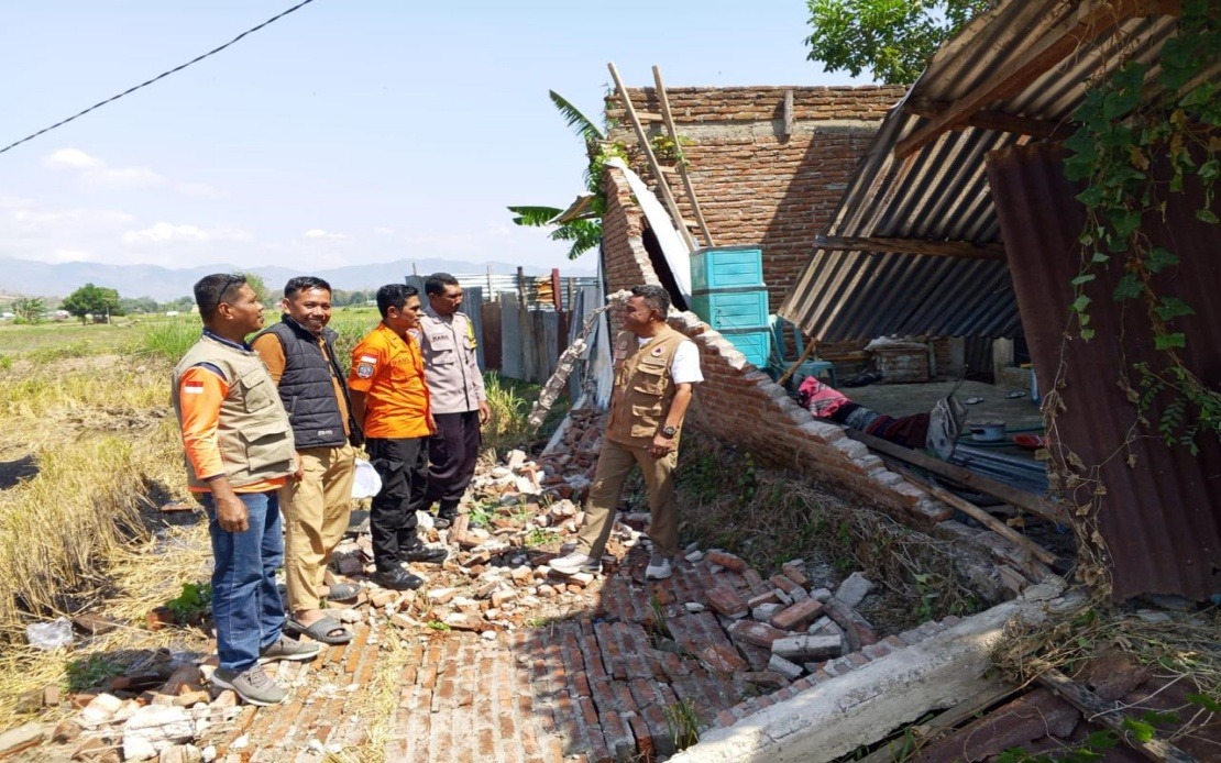
A devastating 7.7 magnitude earthquake struck Indonesia's Flores Island in the East Nusa Tenggara province before dawn on Saturday, triggering a mass evacuation that saw roughly 2,000 residents moved to safety by authorities and emergency services. The initial tremor struck at 4:58 am local time with its epicentre located approximately 30 kilometres offshore from Mbay at a depth of 15 kilometres, generating considerable alarm among island residents who had endured decades of seismic activity in this geologically unstable corner of the archipelago.
The immediate aftermath witnessed coordinated emergency response efforts as the Meteorology, Climatology and Geophysics Agency issued a tsunami warning that rattled coastal communities across the region. However, the alert was subsequently lifted at 7:31 am after comprehensive sea-level monitoring revealed no significant tidal surge, providing relief to authorities overseeing the evacuation. The sequence of events underscores the complex challenge facing Indonesia's disaster management infrastructure when navigating the critical minutes following major seismic events, where decisions about public safety must be made with incomplete information.
According to the National Disaster Management Agency, the confirmed death toll had reached 20 by Saturday, with six additional residents injured and two others reported trapped in collapsed structures. The Maumere Search and Rescue Office coordinated much of the initial response, though the full extent of human casualties remained subject to ongoing verification as ground-level assessments continued throughout the affected districts. These figures highlight the unpredictable nature of earthquake mortality, where building construction standards and population density in affected zones critically determine outcomes.
The structural damage proved substantial across multiple locations, though preliminary surveys indicated considerable variation in impact severity. Authorities documented 54 houses suffering severe damage, nine experiencing moderate destruction, and 11 sustaining minor harm. Beyond residential properties, the earthquake affected critical infrastructure including five health facilities, one educational institution, three religious buildings, a warehouse operated by the state food logistics agency Bulog, and six government office buildings. Such distributed damage across multiple facility types complicates recovery efforts and strains already-limited resources in Indonesia's eastern provinces.
Manggarai district emerged as the epicentre of destruction, recording 29 severely damaged houses alongside nine moderately damaged and nine slightly damaged residences. The neighbouring East Manggarai district reported 23 severely damaged structures, suggesting the earthquake's primary destructive force concentrated in these two administrative regions. The clustering of damage patterns reflects how seismic waves propagate through varying geological substrates, with proximity to the epicentre, soil composition, and local building construction practices all influencing the ultimate impact on communities.
The earthquake generated an extraordinary sequence of aftershocks totalling 111 recorded events, a phenomenon that compounds both the immediate danger to residents and the psychological trauma experienced by communities already destabilized by the primary tremor. Such prolific aftershock activity typically persists for weeks following major earthquakes, forcing displaced residents into extended periods of uncertainty and deterring their return to homes even after structural damage assessments suggest habitation safety. For Malaysian observers, this underscores the regional seismic hazards that affect much of Southeast Asia along the Pacific Ring of Fire.
Communications infrastructure suffered significant disruption across the affected region, with 200 base transceiver station sites experiencing service failures across 10 districts and cities throughout East Nusa Tenggara province. The Digital Infrastructure director-general of Indonesia's Communication and Digital Affairs Ministry reported these disruptions represented 16.35 per cent of total BTS sites in the affected zone, effectively crippling emergency communications precisely when coordinated response efforts required functional telecommunications networks. Mobile operators worked alongside government agencies to restore services, though the degradation of communications capabilities in disaster-struck areas remains a persistent vulnerability across Southeast Asia.
The disaster management response mobilized substantial resources across multiple agencies and hierarchical levels. Regional disaster management organizations coordinated with military and police forces, supplemented by civilian government administration and various support agencies tasked with damage assessment, casualty verification, and provision of humanitarian assistance to displaced populations. This multi-agency coordination model reflects Indonesia's institutional approach to disaster response, though effectiveness often depends on resource availability and coordination quality at district and village levels where ground-level needs concentrate most acutely.
For Malaysia and the broader Southeast Asian region, the Flores earthquake serves as a sobering reminder of the seismic risks embedded within the region's geology. Indonesia straddles the Pacific Ring of Fire and experiences frequent significant earthquakes that occasionally generate regional tsunami warnings affecting Malaysian maritime zones and coastal communities. The incident highlights the importance of maintaining robust early warning systems, building code enforcement in seismically active zones, and regular disaster preparedness drills that ensure civilian populations understand evacuation procedures and safe assembly points.
The disaster also underscores ongoing challenges in disaster risk reduction across Indonesia's eastern provinces, where remoteness, limited infrastructure development, and population dispersion across island geography complicate both prevention efforts and response coordination. Building standards in rural areas often lag behind those in major urban centres, leaving populations in earthquake-prone zones particularly vulnerable to structural collapse. Regional cooperation on seismic monitoring and early warning systems remains an area where Southeast Asian nations could enhance capabilities through shared technology platforms and coordinated scientific research initiatives.
Indonesia's National Disaster Management Agency continued comprehensive ground assessments as of Saturday, with officials acknowledging that impact data collection, verification, and validation remained ongoing processes. This methodical approach reflects lessons learned from previous disasters but also highlights the reality that accurate casualty figures and damage estimates often require substantial time to compile in geographically dispersed, recently traumatized communities. The agency's commitment to transparent communication about assessment progress represents best practice in disaster response communications, though it also illustrates how initial reports to media often require substantial revision as ground truth emerges.
The recovery and reconstruction process will extend far beyond the immediate aftermath, involving rebuilding damaged homes and facilities while simultaneously addressing the psychological and social disruption experienced by evacuated communities. Development organizations will likely provide substantial technical and financial support, positioning this earthquake as a potential catalyst for improved building standards and infrastructure resilience across Flores Island's vulnerable districts.

