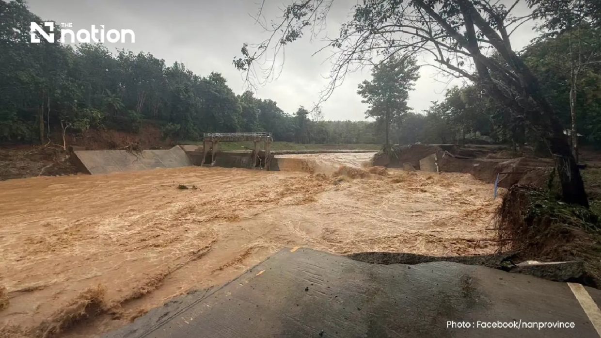
Torrential rainfall inundated Pua district in Nan province throughout Wednesday morning, leaving communities submerged and critical infrastructure damaged as more than 110mm of water fell overnight in the northern Thai highlands. The deluge transformed the forested headwater region of Phu Kha subdistrict into a disaster zone, with rapid runoff overwhelming residential areas, farmland and transportation networks faster than residents could prepare their properties. Authorities responding from around 6am found entire neighbourhoods underwater, with families having barely minutes to salvage belongings before floodwater consumed their homes and livelihoods.
The Doi Phu Kha National Park office confirmed precipitation levels exceeding 110mm had fallen in the early morning hours, setting off a cascade of secondary disasters throughout the district. Ban Rong in Pua subdistrict bore the brunt of the initial flooding, with agricultural zones similarly devastated. The speed and volume of the water movement indicated terrain characteristics typical of upland areas prone to rapid runoff, where steep gradients funnel water downslope with minimal time for soil absorption or drainage systems to respond effectively.
Road infrastructure suffered particularly severe damage, with multiple transport corridors rendered impassable. A bridge in Ban Na Lae along the route toward Doi Phu Kha National Park and Bo Kluea district was completely washed away, severing a critical connection for the region. Similarly, a bridge in the Fai Chao weir area succumbed to the floodwaters, disrupting the Doi Phu Kha route that normally serves as a major passage for vehicles and commerce in the area. The Nan Highway District 2 unit of the Department of Highways identified three distinct locations where road surfaces had become completely impassable, forcing authorities to issue formal traffic advisories directing travellers to avoid the affected corridors entirely.
Beyond flooding, the saturated terrain generated additional hazards threatening lives and infrastructure. Landslides emerged at multiple locations throughout Ouan subdistrict, blocking access roads and hampering rescue and relief operations. Officials tasked with reaching stranded residents and delivering emergency supplies faced obstacles on multiple fronts, as terrain destabilisation compounded the challenges posed by standing water and destroyed bridges. The combination of flooding and slides exemplifies the interconnected risks that extreme precipitation events pose in mountainous terrain, where water movement destabilises slopes already saturated from continuous rainfall.
Evacuation efforts mobilised across the district as the Nan Provincial Disaster Prevention and Mitigation Office coordinated response activities. Residents in affected communities faced harrowing circumstances, with little preparation time before water entered homes. Electrical equipment, vehicles, livestock and personal possessions suffered damage as families prioritised moving themselves and vulnerable individuals to elevated areas. Elderly residents and patients requiring medical support presented particular challenges for evacuation teams working against time and deteriorating conditions.
The Department of Disaster Prevention and Mitigation activated emergency communication systems to warn residents of escalating dangers. Working with mobile network operators AIS, True and NT, authorities deployed Cell Broadcast emergency alerts directly to mobile phones across Pua district. The messages urged residents to immediately relocate valuable possessions upward, evacuate elderly family members and bedridden patients, and contact village leadership or local administrative bodies for rescue assistance. This rapid-alert system represents a critical component of Thailand's disaster response infrastructure, providing real-time warnings to populations in danger zones.
Weather forecasting agencies detected broader rain patterns affecting the northern region. The Thai Meteorological Department's Northern Meteorological Centre identified rain bands detected by Lamphun weather radar across nine provinces in the upper North, with precipitation systems moving south-westward. Light to moderate rain activity across this wider area suggested that Pua district's catastrophic flooding resulted from localised atmospheric conditions concentrating exceptional moisture over the upland terrain, a phenomenon known to produce flash flood scenarios in Thai geography.
For Malaysian readers, the flooding in Thailand illustrates weather pattern risks that periodically affect Southeast Asia's monsoon-influenced regions. Thailand's northern provinces share similar topographical and climatic characteristics with Peninsular Malaysia's mountainous interior and eastern states. The vulnerability of infrastructure such as bridges and roads to flash flood damage reflects challenges that Malaysian authorities also confront during the northeast and southwest monsoon seasons, particularly in states such as Kelantan, Terengganu, and Pahang. The rapid deployment of emergency communications through cell broadcast systems demonstrates a regional best practice that Malaysia itself utilises during disaster situations.
The immediate humanitarian crisis in Pua district will likely persist as floodwaters recede and communities assess damage. Beyond the personal hardship affecting residents, the destruction of agricultural land threatens future food security and farmer incomes across a region where agriculture forms the economic foundation. Road closures interrupt commerce and supply chains, with broader economic effects on regional trade patterns. Thailand's disaster management apparatus will face weeks of reconstruction work, damage assessment and livelihood restoration activities as communities begin recovery processes.
These recurring flood events in Thailand's upland regions underscore broader Southeast Asian vulnerabilities related to climate variability and terrain characteristics. Northern Thailand's position at the junction of multiple monsoon influences creates conditions where atmospheric systems can deposit exceptional precipitation over short timeframes. Similar mechanisms affect Malaysian territories, making cross-border knowledge sharing regarding disaster preparedness, early warning systems and infrastructure design increasingly valuable for regional resilience building. As climate patterns shift, understanding localised flood dynamics becomes essential for protecting populations in Thailand, Malaysia and across Southeast Asia.

