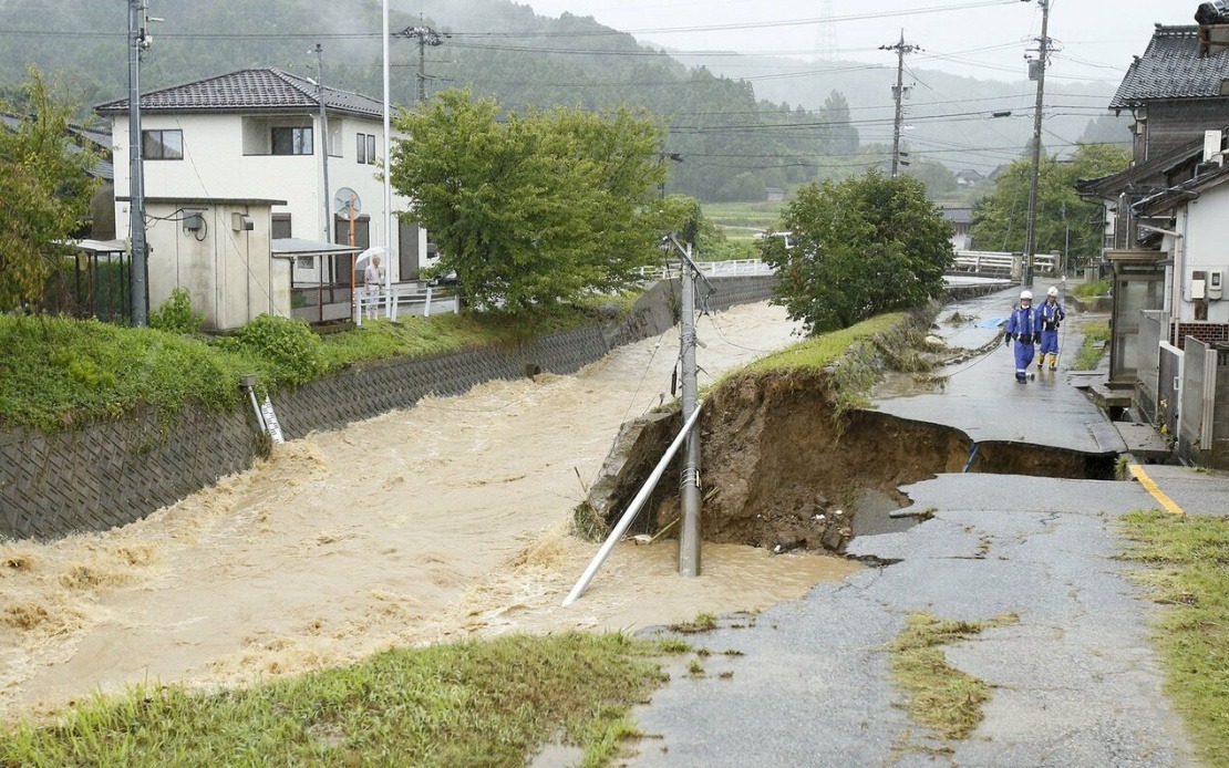
Japan's central regions faced an unprecedented weather emergency Thursday as intense rainfall sparked widespread flooding and landslides across multiple municipalities. The Japan Meteorological Agency activated its maximum alert status for affected areas in Ishikawa and Toyama prefectures, signalling that dangerous conditions had either already materialised or posed an immediate threat to public safety. The severity of the situation prompted authorities to order approximately 180,000 residents across five municipalities to implement immediate evacuation and protective measures as atmospheric instability created life-threatening circumstances.
The most critical zones receiving the Level 5 warning—the agency's highest classification indicating a disaster is occurring or imminent—encompassed Himi in Toyama Prefecture and four communities in Ishikawa Prefecture: Hakui, Shika, Hodatsushimizu, and Nakanoto. These municipalities experienced the brunt of the deluge, with precipitation totals breaking historical records at each location. Within a 12-hour window ending at 7:20 am, Himi and Hakui received over 300 millimetres of rainfall, while Hodatsushimizu recorded more than 200 millimetres, each figure representing unprecedented accumulation for those respective areas.
On-the-ground reports painted a picture of rapid environmental degradation as water systems overflowed their banks and inundated transportation networks. A firefighting corps member in Himi, speaking to news agencies by telephone, described river overflow events and multiple vehicles submerged in floodwaters, illustrating the speed and force with which conditions deteriorated. Though rescue operations were underway, prefectural authorities reported no confirmed fatalities at the time of initial reporting, though the situation remained fluid and potentially unstable.
The meteorological agency attributed the disaster to a frontal system advancing eastward from the Sea of Japan, combined with an extremely unstable atmospheric configuration resulting from a cold-air mass and a deep pressure trough. This system was forecast to progress southward through Friday, with the agency projecting continued heavy precipitation across an expanded region. Hokuriku areas faced expectations of up to 200 millimetres additional rainfall over the subsequent 24-hour period, whilst the Kanto-Koshin and Tokai regions were anticipated to receive up to 150 millimetres.
The crisis extended beyond the initially affected prefectures, as neighbouring Niigata Prefecture also experienced significant rainfall from the same weather system. The geographic scope of the disaster underscored the severity of the atmospheric disturbance affecting Japan's central and western regions simultaneously. The synchronised nature of the rainfall across multiple administrative areas suggested a large-scale meteorological event rather than localised flooding.
This catastrophic sequence arrived merely weeks after a similar extreme weather event had devastated Chiba Prefecture, located nearer to Tokyo. That incident, which also triggered a Level 5 warning, resulted in 13 fatalities and produced widespread vehicle abandonment, with approximately 2,500 cars rendered immobile by floodwaters across the prefecture's road networks. The rapid recurrence of maximum-level weather alerts within such a short timeframe raised concerns about whether Japan's most vulnerable regions were experiencing increasing frequency of extreme rainfall events.
For Southeast Asian observers, Japan's weather crisis carries particular significance. The region's meteorological patterns influence weather systems affecting tropical Asia, and Japan's advanced early-warning infrastructure and evacuation protocols offer instructive models for flood management in countries with comparable geographic vulnerabilities. Malaysia, with its own monsoon-driven flooding challenges and densely populated urban centres, faces analogous risks during peak precipitation seasons, making Japan's crisis response mechanisms worth studying.
The evacuation scale—affecting nearly 200,000 people within hours—demonstrates the logistical complexity of managing mass population displacement during rapidly developing natural disasters. Japanese authorities' capacity to execute coordinated evacuations across multiple prefectures simultaneously reflects institutional preparedness that many developing economies continue to strengthen. The coordination between meteorological agencies, local governments, and emergency services illustrates the infrastructure investments necessary for effective disaster response.
Looking forward, the confluence of climate variability and meteorological intensity raises critical questions about long-term climate adaptation for densely populated regions. Japan, already vulnerable to typhoons, earthquakes, and seasonal flooding, faces the compounding challenge of increasingly erratic precipitation patterns. Similarly, Southeast Asian nations with significant populations in low-lying or flood-prone areas must evaluate whether existing infrastructure and early-warning systems can accommodate intensifying extreme weather events.
The timing and scale of these consecutive disasters suggest that exceptional weather events—once considered anomalies—may reflect evolving climate patterns requiring recalibration of disaster preparedness frameworks. For Malaysia and regional neighbours, Japan's experience serves as both cautionary tale and demonstration of how rapid, coordinated governmental response can mitigate catastrophic outcomes when nature's forces overwhelm traditional preventive measures.

