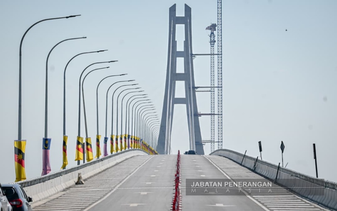
Sarawak has taken a decisive step toward reshaping its economic landscape with the official opening of the Batang Lupar 1 Bridge, a monumental engineering achievement that promises to unleash development across the state's coastal corridor. Spanning the country's longest river, the 4.844-kilometre structure represents far more than a mere crossing—it embodies the state government's vision to knit together previously isolated communities and unlock the economic potential of districts long constrained by geographical barriers. Premier Tan Sri Abang Johari Tun Openg characterised the occasion as historic, signalling a turning point in Sarawak's infrastructure trajectory and positioning the bridge as a catalyst for accelerated growth in agriculture, investment, and inter-district commerce.
The construction of this bridge directly addresses longstanding community grievances that had persisted for decades. Residents of Sebuyau, Betong, Sri Aman and Samarahan have endured the limitations of ferry transport across the Batang Lupar River, a route notorious for operational disruptions caused by treacherous weather conditions. Abang Johari acknowledged these historical challenges, noting that strong waves and winds had previously created safety hazards and occasional tragedies at the river mouth. The bridge therefore resolves not merely a transportation inconvenience but a safety imperative, responding to persistent calls from elected representatives spanning multiple election cycles who championed improved connectivity for their constituents.
The financial commitment underpinning this project—RM848.75 million—reflects the state government's confidence in the bridge's strategic importance. This substantial investment forms a cornerstone of the Sarawak Second Trunk Road initiative, an ambitious multi-billion ringgit programme designed to modernise the state's transportation infrastructure and foster a more integrated regional economy. Rather than representing an isolated infrastructure gesture, the Batang Lupar 1 Bridge functions as a critical nodal point within a far broader transformation of Sarawak's geographical connectivity, demonstrating how major capital works can reshape regional dynamics.
The immediate impact on travel patterns will be dramatic and far-reaching. Journeys that previously required ferry crossings lasting up to an hour can now be completed in minutes, fundamentally altering the calculus of regional movement. More significantly, the bridge reduces the road distance between Kuching and Sibu—two of Sarawak's principal economic centres—from 396 kilometres to 252 kilometres, a reduction of 144 kilometres that substantially compresses travel time and logistics costs. This compression of space has profound implications for economic integration, making it economically viable for businesses to operate across a wider geographical footprint and enabling consumers to access markets and services previously considered inconveniently distant.
Deputy Premier Datuk Amar Douglas Uggah Embas, whose portfolio encompasses infrastructure and port development, positioned the bridge within the larger RM3.21 billion Sarawak Coastal Road network initiative. This comprehensive programme, targeted for completion by 2030, represents a generational commitment to coastal connectivity that extends well beyond the Batang Lupar crossing. The coastal road network will eventually link previously disparate settlements into a cohesive economic zone, with implications for agricultural distribution, tourism development, and manufacturing sector integration. The ferry service that long dominated this route has now become redundant, marking the definitive end of an era characterised by dependence on weather-dependent maritime transport.
The bridge's recognition by the Malaysia Book of Records as the longest river-spanning structure in the country elevates its significance beyond regional importance to national symbolic status. This certification, presented during the opening ceremony, underscores the engineering complexity and achievement involved in constructing such a facility across Malaysia's longest river system. For Sarawak, the designation serves as external validation of the state's capacity to execute world-class infrastructure projects and positions the bridge as a visible emblem of developmental progress in the eyes of both domestic and international observers.
The economic multiplier effects of this infrastructure investment will likely extend far beyond the immediate districts of Sebuyau, Betong, Sri Aman and Samarahan. Agricultural producers in these areas, historically constrained by transportation bottlenecks, now gain reliable access to larger consumer markets in Kuching and beyond. The reduction in transit time and increased reliability of transport pathways will lower distribution costs and improve product quality, potentially transforming agricultural viability in regions that have historically struggled with market access. Similarly, manufacturers and traders will find it commercially rational to establish operations in previously marginal locations, creating employment opportunities and diversifying these districts' economic bases beyond subsistence agriculture.
The bridge's opening also carries implications for inter-state connectivity within Sarawak. By substantially reducing travel time between major population centres, the infrastructure facilitates labour mobility, enabling workers to access employment opportunities across a wider geography. This expanded labour market integration can contribute to more efficient human capital allocation and potentially moderate wage disparities between coastal and interior regions. The enhanced connectivity may also support tourism development, as the coastal corridor becomes more accessible to visitors from Kuching and other established tourist destinations.
From a Malaysian perspective, Sarawak's infrastructure investments underscore the expanding divergence in development trajectories between Malaysia's more urbanised peninsular regions and the state's ongoing transformation. While Peninsular Malaysia has developed relatively integrated infrastructure networks over preceding decades, Sarawak's scale and geographical challenges have necessitated more recent, concentrated investment spurts. The Batang Lupar 1 Bridge exemplifies how strategic infrastructure can function as a lever for regional rebalancing, potentially positioning Sarawak as an increasingly integrated economic space rather than a collection of isolated settlements. This trend carries implications for Malaysia's broader regional development strategy and the distribution of comparative advantages across the federation.
The completion of this bridge also signals the state government's administrative capacity and commitment to executing large-scale infrastructure projects. In an era where government project delivery frequently encounters delays and cost overruns, the successful realisation of this RM848.75 million structure within apparent parameters suggests competent project management and sustained political will. This capability will be crucial as Sarawak pursues the remainder of its coastal road network development programme toward the 2030 completion target. The bridge's successful inauguration thus provides reassurance to stakeholders regarding the feasibility of downstream phases of the larger STRR initiative.
Looking forward, the Batang Lupar 1 Bridge represents merely the foundation of Sarawak's coastal transformation narrative. As additional segments of the coastal road network reach completion over the coming years, the cumulative effects of improved connectivity will compound, potentially catalysing unexpected economic opportunities and demographic shifts. Communities that currently appear peripheral may emerge as attractive locations for investment and settlement, fundamentally reconfiguring Sarawak's economic geography. The bridge therefore merits recognition not merely as an engineering achievement but as a pivotal moment in Sarawak's developmental trajectory, one that promises to reshape settlement patterns, economic activities, and regional relationships across the state's coastal expanse for generations to come.

